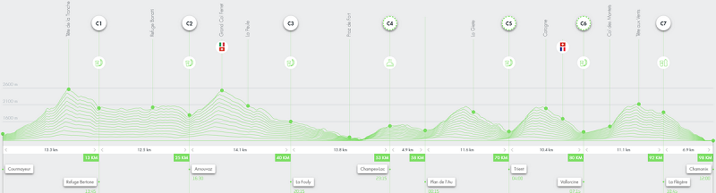
The CCC® is one of the flagship races of UTMB® Mont-Blanc. The course covers a good part of the second half of the UTMB®, but with specificities. If one day you dream of running the UTMB®, the CCC is a race to put on your agenda. Covering a distance of 100 kilometers and 6000 meters of positive elevation, the start from Courmayeur – Champex – Chamonix takes place in the center of Courmayeur in Italy. Find our tips for managing your CCC®.
Contents
The CCC: A long and difficult first climb from Courmayeur
The UTMB® route passes through Courmayeur and the Bertone refuge. Even though the CCC® starts from Courmayeur, the route does not go directly to Bertone.
The start from Courmayeur (around 1200m altitude) creates a unique atmosphere in the village of Courmayeur, to the sound of Vangelis’ “Conquest of Paradise” music. A first stretch of about 1km in the center of Courmayeur allows you to start on a flat surface before slowly seeing the slope rise. The route is wide at the beginning. Even when you reach the first trails, the path remains wide, on a 4×4 track.
The UTMB® climbs to the Bertone refuge on the left at km 3, while the CCC® continues on the 4×4 track until km 4.5 in the hamlet of Tsapy. You have to take advantage of these first 4.5km to find your pace. Because the single trail starts just after this hamlet. After that, it will be very difficult to overtake in the single trail up to Tête de la Tronche at km 9.
When we say to find our pace, it means neither too fast nor too slow… Indeed, it’s 1000m of positive elevation in 4.5km, like a Vertical Kilometer, with a slight respite halfway. Therefore, you should not start too slowly at the risk of getting stuck behind a group that is too slow, but also not start too fast because besides bothering the runners behind you, there is the risk of starting too fast and giving too much while there are still more than 90km to go…
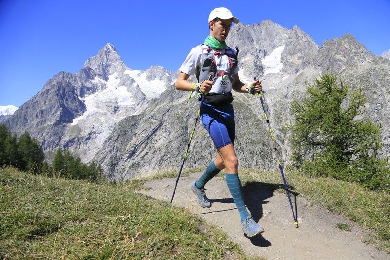
The key word remains caution on this climb to Tête de la Tronche (2584m altitude)! If you have brought poles, they will be out at the beginning of the single trail. Preserve your thighs as much as possible.
The CCC: the switch from Tête de la Tronche to Val Ferret
Once you reach the top of the endless Tête de la Tronche, it’s time to switch to the Bertone refuge. You can then start running at a moderate pace again. The Bertone refuge is at km 13 of the CCC. If the weather is clear, take the time to look at the majestic Mont-Blanc in front of you, and the Grandes Jorasses!
Then there are 12km on a balcony facing Mont-Blanc, like a roller coaster, with a continuous succession of small bumps, most of which are runnable. Try to stay as relaxed as possible, do not put too much intensity on this part. You start the short but quite steep descent towards Arnouvaz at km 25.
Passing through the Grand Col Ferret
You arrive at the end of the Val Ferret, at least in its lower part. You will have to get ready to say goodbye to Italy and climb about 750m to reach the Grand Col Ferret (2537m altitude). Often windy, it will be perceived differently depending on everyone’s sensations. If you have been cautious until now, it is quite steep but regular, and it goes much faster than the Tête de la Tronche! If you have already put too much intensity, it can already strain your thighs.
You arrive at the border between Italy and Switzerland. And less than 5km as the crow flies from Mont Dolent, the France-Italy-Switzerland border.
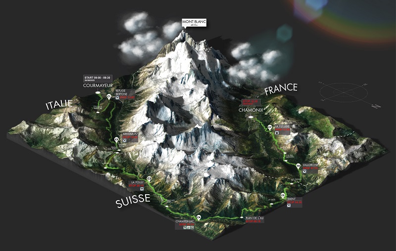
Welcome to Switzerland
Switzerland is welcoming! Through its villages that you will encounter later, but also by offering you a first gentle and lasting descent of nearly 20km! However, be careful, it might be a trap 😉 We often tend to push hard in the descent towards La Fouly. Some runners say that from there, we can start to let go.
It’s, in my opinion, a mistake. You still need to save your thighs. Stay in basic endurance or just slightly above. Because the descent is long. Many runners give too much in this part and end up walking for a long time to recover after La Fouly, while the part from La Fouly to the foot of the Champex Lac climb is largely runnable if you haven’t made any mistakes. The few seconds gained at the beginning of the descent to La Fouly are then paid for in several minutes of walking on the flat afterward.
La Fouly is a typical village, with a very welcoming refreshment station and volunteers. The paths near the Dranse river are very pleasant and offer shade under the trees. We are approaching the climb towards Champex Lac.
The climb to Champex Lac
The climb to Champex Lac is steep but fairly short (about 400D+). It challenges your thighs after a long flat section. You will then need to shorten your steps and use your poles for the rhythm. At the top of the climb, you arrive at the magnificent Lake Champex
The first runners have already passed in the early afternoon, but for many runners, the climb is done at night. In Champex, at km53, a refreshment station is available. It is often said that the CCC truly begins now! Even though, of course, your thighs are no longer fresh.
Don’t hesitate to take a break to start fresh. You have roughly a sequence of 3 climbs and descents of 700 to 800m elevation: Bovine, Catogne, and Tête au Vent.
The sequence Bovine, Catogne, and Tête au Vent
At the start of Champex, along the lake is flat, and the part up to the foot of the Bovine climb is generally runnable.
Bovine climb
Now, you have to deal with less fresh legs and not ask too many questions. The Bovine climb has a slight flattening before a steep but fortunately not too long ascent. The descent to Trient is quite technical, so be careful with the roots if you are passing at night. You will be glad to have trained downhill running!
Catogne climb
Another refreshment station is at Trient, a small Swiss village known for its pink church. We are at km70, and the next climb is still very steep. Fortunately, the slope softens towards the end, and when you arrive at Catogne, the descent to Vallorcine allows you to go quite fast, with a narrow path at first, a wide track towards the ski lifts, and a more technical end of the descent in the forest before reaching Vallorcine.
Vallorcine is the last “complete” refreshment station. There is a little less than 20km left, and if you have good feelings, you know you will make it. If you are struggling, you will have to start cautiously, with a little over 3km on a slight incline up to Col des Montets.
The Tête au Vent – Flégère climb
At Col des Montets, you see the wall rising for the last climb! When you get there at night (generally for runners between 50th and 1000th place), there is almost a poetic aspect. You see the fireflies of runners with headlamps wandering above you. This climb is made up of blocks of stones, in the form of stairs.
The Tête au Vent climb is legendary for CCC and UTMB runners. Those who pass it at night have an even more daunting task because as you reach Tête au Vent, the trail remains very technical until Flégère, with a lot of rocks. Runners in the top 50 and those in the second half of the ranking witness a grand spectacle with a view of the entire Mont-Blanc range!
The arrival of the CCC in Chamonix
Once you reach Flégère, which provides a light refreshment, mainly liquid, you are almost there! The descent to Chamonix is done with what you have left. If you are exhausted or feel pain, you will manage as best as you can. If you feel good, you can put your last strengths into the battle on this descent! It has many hairpin turns but is rather runnable!
When you cross the Arve, all you have to do is savor the last kilometer in the streets of Chamonix. You may already be imagining the finish arch… The applause in the streets. We’ll let you discover the atmosphere at the finish and the emotion of crossing the finish line 😉

Equipment for the CCC
For the CCC, there is a list of mandatory gear. We let you take note of this equipment. Special attention should be paid in case of difficult weather conditions (rain, snow, cold, wind). And of course, your headlamp if you will spend a significant part of the race at night.
Regarding nutrition, the refreshment stations are generally positioned every 10 to 15km, which allows you to refuel sufficiently with water. You can also bring purees, bars, or gels for extra energy between the refreshments. We recommend that you plan your nutrition strategy in advance for your ultra trail.
For me, the CCC 2021 is an unforgettable memory with magnificent landscapes, very mild weather (almost a bit hot), and a well-controlled management to finish in 15h21 (147th).
All that’s left to do is to wish you a good race! And if you read this article early enough, do not hesitate to download RunMotion Coach, the official coach of UTMB® Mont-Blanc to prepare 😉
Image credits: UTMB® Mont-Blanc official website